Who or what is buried on the grounds of the Lebanon Expo Center?
That’s a question that’s perplexed Tim McGowan the past two years.
“I was helping to set up at the fair and someone mentioned, ‘Do you remember that there is a cemetery in there?’” recalled McGowan in an exclusive interview with LebTown. “Well, that’s what sparked it again. I said, ‘Yeah, I remember that. Somebody ought to research it and see what they can find.’”
That somebody turned out to be McGowan, who has become a part-time detective as he tries to unearth clues that would identify individuals whose final resting place is in a small batch of woods next to Rocherty Road in North Cornwall Township.
“You kind of take ownership of it,” said McGowan about the historical mystery. “It is a family plot. There’s no church affiliation. There’s no school affiliation. But you do kind of feel like an Oak Island investigator, if you’ve ever seen that show. In fact, that’s what the guys from the expo said. They said it looked like the Oak Island show out here the other day.”

Although it may not resemble a cemetery in its current condition, there’s little doubt in McGowan’s mind that it is. The comment about the cemetery during set-up for the Lebanon Area Fair released a flood of memories from long ago.
“I remembered the cemetery being here when the road was built,” said McGowan. “I went to Cedar Crest High School and there was no Rocherty Road then. We went under the tunnel north of this. When the road was built and opened, I remember looking down and seeing this. I remember seeing a better wall and the tombstones. That was 50-some years ago.”

Just like a detective who pursues every lead down a certain path, McGown has chased every lead presented to him. But also like a detective, that particular path has led to a dead end more times than not.
The grave markers are limestone and appear to be unmarked, which McGowan says makes some sense since limestone is too fragile to chisel or engrave names and dates. He did offer the caveat, however, that the inscribed text may have weathered over time.
LebTown agreed to assist McGowan’s research by making 3D images of the headstones to share them with readers in case someone is able to decipher any verbiage that may be written on them.


McGowan also consulted with someone he called the “Moss Lady” to determine the age of the cemetery via vegetation and soil depth analyses.
That, however, has also proven to be difficult since the landscape in that immediate vicinity was altered when Rocherty Road was built in the late 1960s. Also, vegetation growth rates tend to vary and may skew the data.
And then there are the competing theories from those McGowan has contacted for their expertise.
“Some believe the large stones are headstones, some think the smaller stones that are in line with the larger ones are footstones, which is a theory in the old days of how they marked the end of a grave,” said McGowan. “Others have thought, no, those are (also) headstones, just older.”
McGowan added that while he’s just an amateur gumshoe looking to solve a mystery in memory of those forgotten souls who are buried there, he has at least been able to cobble together an educated guess about the cemetery’s composition.
“So, I am leaning 75 percent that these are headstones and footstones,” he stated, pointing to an area where about six stones are in a nearly straight line with smaller stones situated in front of and to the east side of them. “That being said, there are (other) upright stones behind this (large) one.”
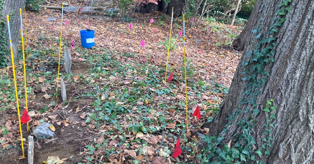
Just recently, a technician used ground-penetrating radar to produce a number of “hits” underneath the surface and other “ground disturbances,” which could be anything from massive tree roots or other large buried objects that would produce a reading.
In at least one case, a large tree has grown over what is believed to be a grave site and against the stone, which impeded radar testing of that particular spot.
“He couldn’t get in here,” said McGowan about the radar technician’s efforts in that area immediately behind the main line of stones. “I don’t think these trees were here when the burials were done.”

The trees that have grown and now loom over the cemetery — along with other forces of Mother Nature and the sands of time — have also complicated matters.
An unanswered question concerns why only a portion of what appears to be a stone wall is visible to the naked eye. In one section the tops of those stones barely rise above the surface while other areas in proximity are missing stones altogether.
McGowan said the L-shaped line of stacked stones on the expo side (southside) of the burial grounds would indicate that a wall was built as a perimeter around the cemetery.
The cemetery’s entrance is also believed to be located adjacent to Rocherty Road since two massive stones that would have served as stepping stones into the cemetery still exist next to the embankment north of the burial plots.
“He (the technician) suggested this could have been the entrance to the cemetery at one time,” said McGowan. “These were like stepping stones. Again, that’s theory.”
Another issue has been locating historical records for that site since it is unknown when the cemetery was first built. McGowan stated that the physical work of clearing the grounds has been easy compared to conducting research, adding the latter has been “the hardest part of the project.”
Significant local historic dates
1683
William Penn settles Pennsylvania
1685
Chester County formed
1729
Lancaster County formed
1753-1763
French and Indian war
1785
Dauphin County formed
1790
Robert Coleman founds Colebrook
1813
Lebanon County formed
1821
Borough of Lebanon formed
Note: All the above are significant dates for the property where the cemetery is now.
1861-1865
Civil War
1951
Elijah H. Arnold bought the farm, which had an address at that time of 705 Evergreen Road
“William Penn settled Pennsylvania and at first this area was part of Chester County,” said McGowan. “Then it became Lancaster County in 1729, Dauphin County in 1785 and later Lebanon County in 1813 before it became the Borough of Lebanon in 1821.”
While the sleuthing has turned up, at times, more questions than answers, headway has been made into who may be buried beneath the handful of headstones situated in a straight line inside the 38-by-38-foot plot. (If it’s determined that there are corresponding footstones, the number of known deceased in that section would decrease by half to six.)
A tip turned into a hot lead after McGowan made a Facebook post on his personal page concerning the cemetery’s address, which he learned was at one time listed as 705 Evergreen Road. That led to McGowan discovering that Elijah H. Arnold had purchased in 1951 the farm that is now the expo center.
McGowan then contacted one of Arnold’s descendants to gather additional information.
“He (Elijah) lived in Cornwall and passed away a few years ago in his 90s, I believe,” said McGowan. “It was his granddaughter I talked to, I think. She said, ‘Yep, Pap wanted to know more about this and he hoped somebody would do something to it.’ No one ever did and he went to his grave not knowing more about it either. If he did know (anything), he took it along with him.”
Discovering Arnold owned the farm in the 1950s was a major break in the case since it gives a launching point to research property deeds that predate that one.
“What I need to find is who Elijah bought from and who that person bought from and so on back to the ‘beginning,’” wrote McGowan in a follow-up email to LebTown. “In that span, we will have the owner, then we must search records for owner possessions and lists of things left to relatives. Or anything that will lead us to the permanent residents of the cemetery. It will be nice if we can find death records then for the time span related to the owners.”
Since McGowan runs his own photography business, he would like to work with a history major wishing to do research as part of their studies or even a group with an interest in local history. If he is unable to achieve that goal by winter, then he will do additional research himself.

Read More: His Lebanon Area Fair pictures are worth a thousand words – and then some
Through his investigations into archival records and discussions with historians, McGowan has learned some historical facts that have helped answer a few questions and frame what life was like in the region between 1683 and 1861.
“We know that people have traditionally buried their loved ones facing east and these stones face east,” said McGowan. “We also know that limestone headstones pre-date the Civil War. We also know this area had a lot of Swedish and German settlers.”
Asked to hazard a guess as to who may be buried there, McGowan, who has some theories, pauses a few seconds before giving a response. “Very early settlers, very early immigrants, and I’ll just leave it at that.”
If identifications are made, McGowan plans to place a plaque in memory of those specific people at the site. If not, he will recognize the burial grounds with a marker in their memory.
At times, McGowan has wondered what the circumstances were that led to the deaths of those unidentifed individuals. Learning their names and any details about their lives and/or their deaths would be like cracking two cold cases in one.
“It’s a mystery you’re trying to solve. I don’t know that I’ll ever solve it, but hopefully one day someone will.”
Editor’s Note: Anyone interested in assisting McGowan with this project or who may have more knowledge about the cemetery’s origins is asked to contact him via his Facebook page or by email at tmstudio@comcast.net.
Questions about this story? Suggestions for a future LebTown article? Reach our newsroom using this contact form and we’ll do our best to get back to you.

Join our community of local news champions.
Cancel anytime.
Monthly Subscription
🌟 Annual Subscription
- Still no paywall!
- Fewer ads
- Exclusive events and emails
- All monthly benefits
- Most popular option
- Make a bigger impact
Already a member? Log in here to hide these messages
Quality local news takes time and resources. While LebTown is free to read, we rely on reader support to sustain our in-depth coverage of Lebanon County. Become a monthly or annual member to help us expand our reporting, or support our work with a one-time contribution. Cancel anytime.