The Pennsylvania Historical & Museum Commission reminded folks this week that December 1 is the deadline for nominations of properties or locations with historical significance for consideration in the State Historical Marker Program for 2019.
Since its beginning in 1914, program has seen more than 2,500 markers put up around the commonwealth. 30 are located in Lebanon County.
The only catch is that applicants are responsible for costs incurred in erecting the marker. Expect to spend about $2,060 for a roadside marker or about $1,620 for a smaller marker, not including installation costs.
Here are some guidelines to keep in mind:
- The subject to be marked had a substantial connection to Pennsylvania
- The person, place, event, or innovation to be marked had a significant impact on its times, and has statewide and/or national, rather than local or regional, historical significance.
- The significance of the subject must be historically established rather than of contemporary interest.
- A marker cannot be approved for a living person.
People, places, events, and innovations already marked with existing monuments or markers receive less favorable consideration for a PHMC historical marker.
Send your nomination form to: State Historical Marker Program, Pennsylvania State Historic Preservation Office, PHMC, 400 North St., Second Floor, Harrisburg, PA 17120-0053.
Find more information on the Pennsylvania Historical & Museum Commission website.
List of all Pennsylvania Historical Markers in Lebanon County
“Indiantown”
Location: Fisher Ave. (PA 934), just S of Jonestown Rd. and the Swatara Creek, Harper Tavern
The native village from which, in turn, the Creek, Gap, and great Military Reservation derived their names, formerly stood near here. The Delaware Indians took this route to Shamokin, upon their removal from the Schuylkill region.
Blue Mountain forest
Location: Jonestown Rd. (old US 22), near intersection with PA 934, at Harper Tavern
In 1763-64, from a line of six loghouse stations to the north, settlers were defended by the Paxton Rangers – volunteers paid by Pennsylvania’s Provincial government. Fort Hunter was on the Susquehanna just north of Blue Mountain, and the other five stations were just south of the mountain – located at regular intervals over the 23 miles between the river and the Swatara Creek. A similar line of stations had existed, 1756-57.
Cornwall Banks
Location: Boyd St., Cornwall, at now abandoned mine
One of the world’s greatest iron mines, the oldest operated continuously in the New World. It has been mined for more than two centuries, and is still the greatest iron ore deposit west of Lake Superior.
Cornwall Furnace
Location: Rexmont Rd. at site in Cornwall
Built by Peter Grubb. Operated from 1742 to 1883. Administered by the Pennsylvania Historical and Museum Commission.
Cornwall Furnace
Location: Boyd St. (old US 322) near Rexmont Rd., Cornwall
Charcoal iron furnace built by Peter Grubb, operated 1742-1883. Best surviving example of the early Pennsylvania ironworks. Now a State historical shrine, gift of Mrs. Margaret Coleman Buckingham, heir of its famous owner, Robert Coleman.
Cornwall Iron Furnace
Location: Rts. 322 & 419, near Quentin, W of Cornwall
Built in 1742 by Peter Grubb near an immensely rich ore deposit and acres of forest for making charcoal fuel. A self-sufficient community included the ironmaster’s mansion and workers’ houses. The furnace produced pig iron and cast goods, and cannons for the Revolutionary War. Sold in 1798 to entrepreneur Robert Coleman; operated until 1883. It survives fully intact a few miles east at Cornwall.
Fort Swatara
Location: PA 72, about a mile N of Lickdale
Originally built by Peter Hedrick, 1755. The stockaded blockhouse was improved in early 1756 by Capt. Frederick Smith to guard Swatara Gap and protect the frontier settlements. The site is on Bohn Lane about a half mile from the intersection.
Fort Zeller
Location: PA 419 (Main St.) at Ft. Zeller Rd., Newmanstown
The State’s oldest existing fort is half a mile to the north. Pioneers who came to the Tulpehocken from the Schoharie valley built it in 1723, rebuilt it in 1745. It was used as a place of refuge during Indian wars.
Grubb’s First Forge
Location: Boyd St. & Gold Rd., Miners’ Village, Cornwall
Peter Grubb (c.1700-54) carried on his initial efforts at iron-making in 1735 just slightly to the north. He used the Catalan-type forge which had originated in Spain sometime during the tenth century.
Indiantown Gap Military Reservation
Location: Fisher Ave. (SR 4020), N of I-81, across from Biddle Rd. entrance to Fort Indiantown Gap
Authorized in 1929, first land bought in 1931, and first used by the National Guard in 1932. In 1940 it was leased to the Federal government as an Army cantonment. Total area now more than 16,000 acres.
Jacob Albright
Location: Pa. 897 near Main & Shad Sts., Kleinfeltersville
The son of German immigrants, Jacob Albright (1759-1808) founded the Evangelical Association, preached to poor farmers, and rose to become Bishop in the Methodist Church. His grave is nearby at Albright Memorial Church.
James Lick
Location: U.S. 22 near junction Pa. 343 just S of Fredericksburg
The California financier and philanthropist, donor of the Lick Observatory, was born in Fredericksburg, Aug. 21, 1796. The Lick family monuments may be seen in the local cemetery.
John Walter
Location: Old US 22 W of Ono at cemetery
Co-laborer of Jacob Albright in founding of Evangelical Church, born 1791, died 1818, is buried in this cemetery. An effective preacher and hymn writer, he published the first songbook for his church.
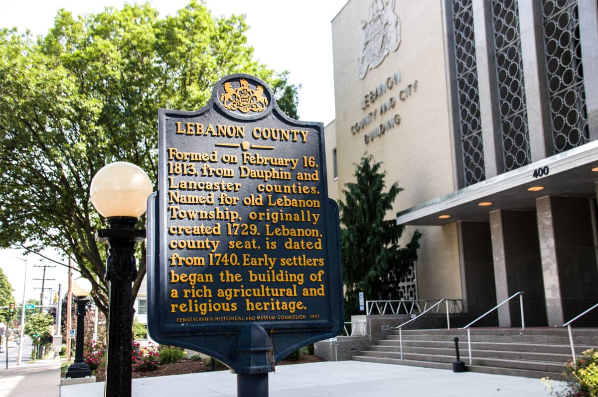
Lebanon County
Location: County-Municipal Bldg., 400 S. 8th St., Lebanon
Formed on February 16, 1813 from Dauphin and Lancaster counties. Named for old Lebanon Township, originally created 1729. Lebanon, county seat, is dated from 1740. Early settlers began the building of a rich agricultural and religious heritage.
Lindley Murray
Location: Corner of Bellegrove Rd. (PA 934) & Jonestown Rd., across from Harper Tavern, East Hanover Twp.
Famous grammarian, author of the English Grammar, was born June 7, 1745, in a house near this point. Robert Murray, his father, owned a mill here from 1745 to 1746.
Lindley Murray
Location: PA 934, .2 mile N of US 22, Harper Tavern
Famous grammarian, author of the English Grammar, was born June 7, 1745, in a house on Indiantown Creek near this point. Robert Murray, his father, owned a mill here from 1745 to 1746.
One Red Rose – Caspar Wistar
Location: On church at 963 Tulpehocken Rd., near Reilly Rd. (T409) and Berks County line, just east of Myerstown
One red rose is annually paid by Trinity Reformed Church to the heirs of Casper Wistar, of Philadelphia, who in 1738 gave one hundred acres of land for church purposes. The congregation was formed by Reformed families among the Tulpehocken settlers…
Pennsylvania Chautauqua
Location: Pa. Route 117 and Carnegie Ave., Mt. Gretna
One of over 200 Chautauquas created as part of a late 19th , early 20th C. movement that began in 1874 at Lake Chatauqua, NY. It grew to include many programs in the arts, sciences and religion and sought to educate people of all social standings. The PA Chautauqua opened here in 1892 on land that was later purchased from industrialist Robert Coleman; over time a number of public buildings were constructed to further its mission.
Reed’s Fort
Location: Allentown Blvd. / Wm. Penn Hwy. (US 22), E of Fisher Ave. (PA 934), just W of Ono (south side)
Just south of this point stood the house of Adam Reed, Esq. In 1755 it was turned into a fort. Here, with Rangers from Hanover Township, Reed protected the people of the countryside against Indian raids.
Reed’s Fort
Location: Allentown Blvd. / Wm. Penn Hwy. (US 22), E of Fisher Ave. (PA 934), just W of Ono (north side)
Just south of this point stood the house of Adam Reed, Esq. In 1755 it was turned into a fort. Here, with Rangers from Hanover Township, Reed protected the people of the countryside against Indian raids.
Sattazahn Lutheran Church
Location: At church on Green Point School Rd., N of Pa. 443 near Murray
Founded by German immigrants who settled as early as 1729. Initially served by traveling missionaries including John Caspar Stoever, Jr., first Lutheran pastor to visit regularly. A log structure was built about 1756; this church erected 1872. Named in honor of Peter Sattazahn, Revolutionary soldier buried here.
Schaefferstown Water Company
Location: Fountain Park at S. Market St. & Sheep Hill Rd., Schaefferstown
One of North America’s oldest documented public water systems. Alexander Schaeffer built a hotel on the square in 1744, and construction of the water system began shortly after. On July 16, 1763, he and his wife Anna Engle deeded this land–today Fountain Park–for the use of the inhabitants of Market Street. The present company was chartered in 1845 as successor to The Fountain Company of Heidelberg.
Swatara Gap
Location: PA 72 just SE of 81 underpass, 2 miles N of Lickdale, near Inwood
This gap in the Blue Mountain, named for Swatara Creek, was a gateway through which enemy Indians came to raid frontier settlements during the French and Indian War. Fort Swatara was built nearby to guard it.
Transporation Corps Unit Training Center
Location: Fisher Ave., near Quartermaster Rd., Ft. Indiantown Gap, Annville
A stevedore training program was established in 1942 at Fort Indiantown Gap. Soldiers were trained to load and unload cargo using three wood and concrete dry land ships. Many recruits were African Americans whose companies were segregated from their parent port battalions during instruction but not in WWII combat locales such as Italy and Normandy Beach on D-Day. Training provided here enabled efficient operations instrumental in Allied victory.
Tulpehocken Evangelical and Reformed Church
Location: Benjamin Franklin Hwy. / E Lincoln Ave (US 422) near E Main Ave., 3 miles E of Myerstown
Organized in 1727 by Tulpehocken settlers. Since 1745, one red rose has been paid annually by the Church to the heirs of Caspar Wistar as rental for the land granted by him for erection of the second place of worship. Since 1902, a white rose, a token of appreciation, has been given to Wistar”s descendants.
Union Canal
Location: US 422, 1 mile W of Myerstown
This canal was in use from 1828-1884. About .3 mile south at the Tulpehocken, are remains of one of the locks by which boats descended from the summit level north of Lebanon to the Schulkill at Reading.
Union Canal
Location: PA 72 S of PA 443 junction and NW of I-81 underpass, near iron bridge, 4 miles NW of Lickdale
Following the Swatara Creek from Pine Grove to main line of the Canal at Water Works was a Feeder Branch. It was in use from 1832-1862. A portion of the Big Dam, a guard lock, and several lift locks remain on the other side of the Swatara.
Union Canal
Location: PA 72, 5 miles NW of Lebanon
After entering the reservoir at the Big Dam in Swatara Gap, water from Swatara Creek came down the branch canal to the Water Works, 3.7 miles southwest of here. At that point it was raised by water wheels and steam pumps and carried by a feeder tube to the summit level near Lebanon. From there the canal descended eastward to Reading and westward to Middletown.
Union Canal Tunnel
Location: At site on Tunnel Hill Rd. (SR 4001) near W Maple St. / Ebenezer Rd.(PA 72) junction, NW of Lebanon
Monument to first canal tunnel in America stands not far up this road. Built in 1823 under this ridge, the tunnel may be reached by a short walk down the hill on either side. The Union Canal was opened in 1827, and operated until 1884.
Union Forge
Location: SR 1020 just E of Pa. 72, Lickdale
Site of a charcoal iron forge begun about 1782 by Curtis Grubb, owner of Cornwall Iron Furnace; a major user of Cornwall iron. Such forges transformed brittle pig iron into workable wrought iron. Union Forge included 1,000 acres of land, blacksmith and carpenter shops, a grist mill, and several houses. Under different owners, the forge was in regular operation until 1868. By then, rolling mills were displacing forges as refiners of iron.

