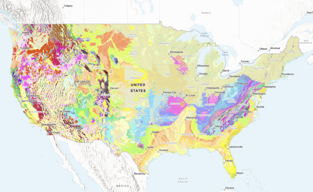
Pennsylvania’s Lebanon Valley, along with regions to the east and west, is covered with a broad swatch of pink – the color indicative of sedimentary rocks dating to the Ordovician period.
Specifically, the region boasts “carbonate and clastic sedimentary rocks,” according to the legend accompanying a new online map from the U.S. Geological Survey, and “includes some metasedimentary rocks primarily in the Appalachian orogen.”
In layman’s terms, as explained by the National Park Service, the Ordovician period lasted for 41.6 million years, ranging from 485.4 million years ago to 443.8 million years ago. During that period, the park service explains, “marine fauna increased fourfold,” with the seas teeming with bivalves, gastropods (snails), bryozoans (moss animals), and crinoids (sea lilies). The first coral reefs appeared in the oceans, and some plants and arthropods began moving for the first time onto dry land.
Oh, and the Appalachian Mountains began to form. Then, the Ordovician period came crashing to an end – geologically speaking, that is – when the supercontinent Gondwana passed over the South Pole, where massive glaciers were formed and the sea levels dropped, leading to a mass extinction of species from that time.
And it all happened right here in Lebanon County …. and, well, lots of other places in the world, too.
It’s all detailed in “the most detailed national-scale geologic map of the country to date,” released recently by the U.S. Geological Survey and touted as “a significant advancement for geoscience … offering a unique regional view of geology at and beneath the Earth’s surface.”
According to an Aug. 28 press release, the new USGS map, called The Cooperative National Geologic Map, was created using more than 100 preexisting geologic maps from various sources and is the first nationwide map to provide users with access to multiple layers of geologic data for one location. This feature allows users to access the multiple data sources included in the map to look at or beneath the surface to understand the ancient history of the nation recorded in rocks.
“Geologic maps have many uses, such as helping experts look for energy, mineral and water resources,” Christopher Swezey, USGS National Cooperative Geologic Mapping Program coordinator, explained in the release. “They can also be used to assess earthquake risks and inform decisions about land use, infrastructure and community planning, and real estate and insurance.”
Geologic maps use different colors to show various types of rocks and sediments beneath the surface. These are organized into geologic map units, which range in composition from loose sand and gravel to very old bedrock. Each unit has its own unique characteristics, such as age and composition.
These layers can offer new insights into the geology of the nation, enabling more efficient analysis of natural hazards and geologic resources, such as potential focus areas for critical minerals vital to national security and economic development. Currently, the map covers the lower 48 states, but plans are underway to add content for Alaska, Hawaii, and the U.S. territories.
While a view of the greater United States shows some areas in vast, homogenous splashes of color representing just one or two geologic types, much of the Appalachian range – including Lebanon County – is tightly banded with a wide variety of eras in colorful evidence.
The band covering Fort Indiantown Gap, for instance, is a blue-gray hue indicating sedimentary rocks from the Late Devonian period – mostly sandstone and mudstone with minor carbonate rocks. The region north of Cornwall and Schaefferstown is a shade of orange, also indicating sedimentary rocks but this time from the Cambrian era – in other words, carbonate and lesser clastic sedimentary rocks.
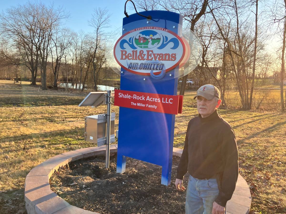
According to Lebanon County’s Natural Resources Plan, the geology underlying most of the county includes coal, limestone, dolomite, sandstone, shale, quartzite, and phyllite materials. Older formations in the southeastern corner of the county include gneiss, granite, anthracite, metadiabase, metabasalt, metarhyolite, and marble. Overall, the Lebanon Valley is largely composed of limestone and dolomite carbonate rock formations totaling over 73,700 acres, or 31% of the county.
Other swatches of color through Lebanon County on the USGS map include a deep violet (sedimentary rocks from the Silurian period), a duller purple (sedimentary rocks from the Middle Devonian to Early Devonian periods), and an aqua (sedimentary rocks from the Pennsylvanian period). Head to Pottstown for sedimentary rocks from the Triassic period, while down in Lancaster they have an iron gray indicating sedimentary and metasedimentary rocks from the Paleozoic. To the west, Hershey and Harrisburg are part of the same pink Ordovician stretch that covers Lebanon, while further east, Philadelphia is found in a band of yellow, indicating coastal zone sediment from the Quaternary period.
According to the press release, the new interactive web tool “was designed to be as user friendly as possible, making it accessible to both geologists and the public. Users can search for specific properties of geologic units or click on the map for additional geologic information and links to more detailed maps of local areas.”
“This map provides complete, analysis-ready geologic data for the nation, in a format that is easy to expand going forward” said Joseph Colgan, a USGS research geologist and leader of the team that created the map. “By providing this map online, we aim to enhance educational engagement and foster a greater public appreciation of geology.”
In addition to public use, it is anticipated that primary users of the map will include federal agencies, private industries, and educational institutions. A recent cost-benefit study highlighted the usefulness of geologic maps with its findings that the value of geologic maps is up to 10 times greater than the cost of their production, the release said.
Read more about Lebanon County geology:
- Unraveling age-old mysteries of Swatara Creek: A journey into geologic time
- Lebanon’s most amazing geological feature by a long-forgotten resort in Cold Springs
- Swatara State Park fossil site offers a glimpse into an ancient past
- At the top of the county, the magnificent Boxcar Rocks are one of Lebanon’s best hiking spots
- What exactly is the ‘Jonestown Volcano’?
Questions about this story? Suggestions for a future LebTown article? Reach our newsroom using this contact form and we’ll do our best to get back to you.
Be part of Lebanon County’s story.
Cancel anytime.
Monthly Subscription
🌟 Annual Subscription
- Still no paywall!
- Fewer ads
- Exclusive events and emails
- All monthly benefits
- Most popular option
- Make a bigger impact
Already a member? Log in here to hide these messages
An informed community is a stronger community. LebTown covers the local government meetings, breaking news, and community stories that shape Lebanon County’s future. Help us expand our coverage by becoming a monthly or annual member, or support our work with a one-time contribution. Cancel anytime.