A decision by canal officials to build the Union Canal north instead of west of Lebanon had ramifications beyond the direction it would eventually travel.
The directional change necessitated a tunnel being built, led to a town’s name being changed, the town later becoming an outdoor destination, and the Union Canal extending to Pine Grove in Schuylkill County.
One of the early designs of the Union Canal called for the planned path to follow the Quittapahilla Creek through Lebanon until it reached Swatara Creek north of Palmyra. But that design was problematic, according to Jim Schucker, a former member of the Friends of the Union Canal who has conducted research and published articles about the Union Canal based on Dean Aungst’s book, The Union Canal and the Lehmans.
“While this location would have provided a better bed for the canal, it was felt that the Summit Level needed the water of the Swatara more quickly so why not swing the canal north to meet the river at its southernmost point, the point where the Water Works was later constructed,” said Schucker.
The canal was routed through the Borough of North Lebanon and, after cutting through Gravel Hill with a tunnel (under present-day Tunnel Hill Road), it met the waters of Cattail Run, which was later renamed Clark’s Run. This stream was dammed in 1866 to create a reservoir called Lions Lake.
Not only did the decision to go north lead to the construction of the “Old Tunnel” but also the renaming of the town of Alger to Union Water Works. Today, Union Water Works is more commonly known as Water Works and is an unincorporated town located in North Annville Township along the Swatara Creek.
Water Works became a thriving town and a popular destination after the canal and dam were built. It was also a key location for the canal’s operation since it is where the Union Canal joined the Swatara Creek and followed it to the Susquehanna River at Middletown.
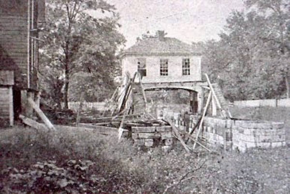
Water Works was home to the canal company’s pumping and weigh stations, toll house, several nearby locks, and a dam used for numerous year-round recreational activities, including year-round fishing, swimming in the summer and ice sports in the winter.
Read More: Water Works was once a popular destination in the Lebanon Valley

“It was also the site of several repair shops used by carpenters and smiths in the employment of the canal company,” said Schucker. “Boats occasionally were made and repaired there, and one of the two weigh locks on the Union Canal used to determine tolls, operated at this location.”
Also established in the town were a hotel, general store, grain mill, lumber yard, community park, and the Union Water Works Church. Built in 1843, the church is now called Waterworks Mennonite Fellowship, according to Craig Meyer, administrator of the North Annville History Group Facebook page.
“It became kind of a resort area, too,” said Schucker. “The stream that comes in is called Clark’s Run or Kettle Run … the canal followed that stream out to the area of the Water Works and then they dammed that up to create a reservoir or a lake. And then there were cottages around there that were a summer retreat.”
To understand why the town of Alger became Union Water Works, you have to know its purpose within the Union Canal as a feeder canal.
“That area was simply used to impound water for the canal,” said Schucker. “They built the dam across the Swatara and put a lock in it and that was to hold water back for the dry season. Water was always a problem for the canal.”
In one of his published articles, Schucker wrote: “Instead of being allowed to enter the Swatara, however, a mile-long dam built along the river stopped the flow of Cattail Run (aka Clark’s Run or Kettle Creek) and created a pool of water known as the Water Works Dam or reservoir.” (Stoever’s and Strack’s dams were also built to supply water to the canal.)
Schucker said a second supply of water feeding the man-made lake came from the Branch Canal, which entered the pool from the north.
He wrote: “A 40-foot-high dam had been placed across Swatara Grap where the river moves through the Blue Mountains (today where Interstate 81 intersects Route 72) impounding a tremendous amount of water. This structure became known simply as ‘The Big Dam.”’
Schucker explained that a huge lock for this dam allowed boats to pass this location on the branch canal and regulated the flow of water through the canal south to the Water Works so that the level of water in the Water Works Dam was maintained at a set level.
“This second source of water was critical during the dry months of the year when much smaller streams such as Cattail Run became but a trickle,” he wrote.
While the dam at Water Works was positioned higher than the Swatara Creek, it was still much lower than the canal’s summit. The problem was to get water uphill to the summit, and that issue led canal officials to build massive water wheels to power four pumps at Water Works.
Two 40-foot water wheels were installed to power four pumps that forced water through iron pipes to the top of a nearby 93-foot-high hill. The wheels, which measured 10 feet in width, were housed in a stone structure known as the Water House.
“It took seven times the amount of water from the Water Works Dam to turn the pumps than the amount of water the pumps were able to lift to the top of the hill,” said Schucker. “When the water reached the top, a structure called The Receiver accepted all the water before it began its journey back to the summit (in the Lebanon area near the Old Tunnel). They started with a water wheel at first, but that wasn’t very efficient.”
A lack of water and the inefficiency of the water wheels led company officials to purchase engines to pump the water. Two such engines were known as “The Merrick Engine” from Philadelphia and the “Cornish Engine” – although the latter was deemed a failure after a short period and was shut down.

“When in full operation, 12 million gallons of water were returned to the summit from the Water Works every day,” added Schucker.
He noted that the feeder canal began at the Water Works dam.
“Here the towpath for the mainline was on the south side of the canal,” said Schucker. The branch crossed over the top of the Water Works dam high above the Swatara and began its trek along the eastern shoreline of the Swatty ’til it reached Jonestown. At the southern edge of Jonestown an aqueduct 175 feet long, referred to as the Blue Rock Aqueduct, brought the towpath and canal to the western side of the Swatara where it continued north.”
Schucker said the canal was originally to end at the northern point of the slackwater created by the Big Dam, and added that land speculators bought parcels of land hoping to develop it near the canal’s terminus.
“A lot of the canal people – or some of the canal people – speculated on land up there because they thought that was going to be the terminus,” said Schucker. “The canal people decided, however, to go all of the way to Pine Grove to bring coal down.”
The canal terminated in a 200-foot-wide and half-mile-long basin in Pine Grove, he said. Here, coal was offloaded from trains onto ships before being transported 22 miles south to the canal’s mainline at Water Works.

Interestingly enough, Alger would never have become Union Water Works if canal officials remained with their original canal route, according to Schucker.
He said the Quittapahilla is a natural basin and while it made sense to follow its path from Lebanon to Palmyra, canal officials decided to plot a different route.
“They originally wanted to stay in the Quittapahilla until it emptied in the Swatara in Myerstown. But they realized they better head for the Swatara at a shorter distance. The shorter distance there is where the Water Works is now, that’s the southernmost part of the Swatara,” said Schucker. “That necessitated the tunnel, Hill Tunnel, that cut through there and then when they got there, they wanted to make sure the Swatara had enough water in the dry season, so that’s why they built the dam (at Water Works) across the Swatara.”
Little evidence remains that would indicate Water Works was once a thriving community flooded with industries with ties to the canal and other local businesses. When the canal disappeared, so did many of the businesses associated with it, according to Schucker.
The canal’s former Weigh Station building sits on a homeowner’s property, a sign for the former icehouse business remains above the garage of Dale Gruber’s residence, and the hotel, situated next to the Ice House, has been converted into apartments.
Although the lake remained long after the canal was closed in 1885, the recreational industry that was prevalent for so many years eventually dried up too after the dam broke and depleted the lake of its water following Hurricane Agnes in 1972.
Questions about this story? Suggestions for a future LebTown article? Reach our newsroom using this contact form and we’ll do our best to get back to you.

Be part of Lebanon County’s story.
Cancel anytime.
Monthly Subscription
🌟 Annual Subscription
- Still no paywall!
- Fewer ads
- Exclusive events and emails
- All monthly benefits
- Most popular option
- Make a bigger impact
Already a member? Log in here to hide these messages
An informed community is a stronger community. LebTown covers the local government meetings, breaking news, and community stories that shape Lebanon County’s future. Help us expand our coverage by becoming a monthly or annual member, or support our work with a one-time contribution. Cancel anytime.

