Artificial intelligence has hit the streets of Lebanon.
The city is improving employee efficiency and enhancing asset management by incorporating the use of AI into its public works department.
Chad Yeagley, director of public works for Lebanon city, said he saw this kind of AI firsthand while working with the U.S. Army Corps of Engineers during a tour of duty in Afghanistan.
“Fast forward to when I took this position and seeing the conditions of the roadways and the streets, I thought to myself, there’s gotta be something that’s similar now on the civilian market that would do kind of the same thing,” said Yeagley. “And coincidentally, maybe it was by divine appointment, but Daniel reached out. I was already looking at a similar software, but apples to apples, this offers way more. So I don’t even think it’s really comparing apples. This product does a whole lot more.”
City officials last fall purchased AI programming from German-based vialytics, whose products allow municipal governments to manage roadways and other highway-based assets, according to senior sales manager Daniel Laufer. Laufer said the city has been using it since Dec. 1.
“As an early adapter, we packaged all of the functionality into one flat fee for the year for unlimited use and that is at around $17,000 annually,” said Laufer. “It is priced on centerline miles. We also waived training and set-up fees and the iPhones and provided significant discounting on the system.”
Over the first few months of 2024, public works staff have been learning how to use the technology on its 96 miles of highway within the city’s border.
“There’s this new buzzword AI, and this uses AI to help solve modern-day challenges in roads and what has now become asset management as it pertains to municipalities, cities, counties, things of that nature,” said Laufer.
Laufer said vialytics’ tools are easy to use, adding, “If you know how to order a pizza, you can use vialytics to do road condition assessment.”
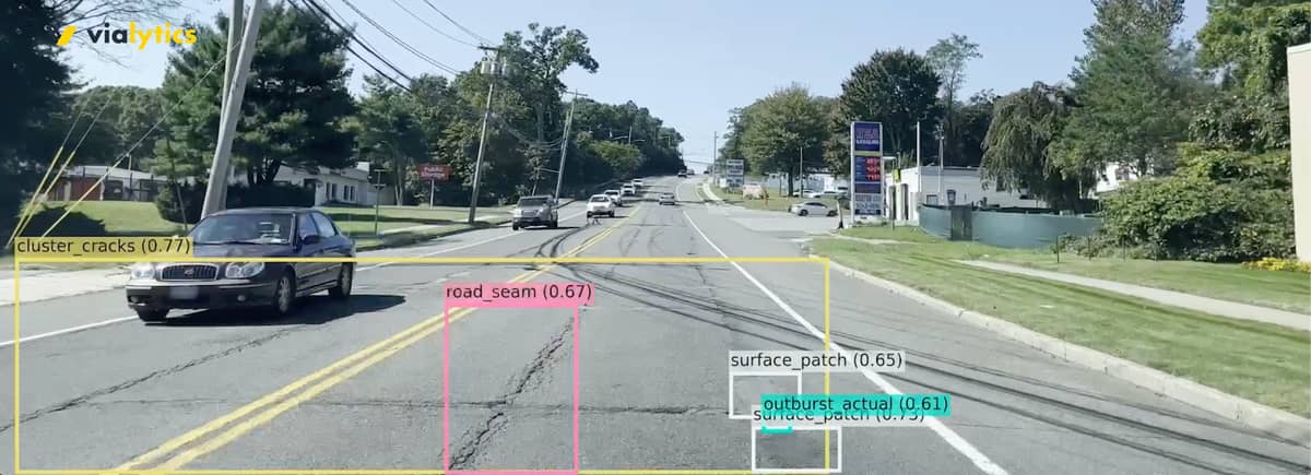
Vialytics is an AI-based road and asset management tool that is used by mounting an iPhone to the windshield of any municipal vehicle and going for a drive. The system captures data about every 10 feet and stores the imagery for download later.
“Vialytics’ advanced AI enables users to automatically record the condition of a roadway and asset infrastructure, plan repairs based on up-to-date data, and centrally manage all maintenance tasks – saving time, manpower, and money with one simple tool,” said Laufer.
The company states the following benefits of using their system, which was developed in 2018:
- Increased value: Leveraging AI and digital imagery, the tool significantly enhances the quality, value, and longevity of community infrastructure.
- Objectivity in assessments: The use of AI eliminates human bias, ensuring all infrastructure assessments are based on consistent, objective criteria.
- Consistency and accuracy: With advanced algorithms, the software provides consistent and accurate analysis of road conditions, enabling more reliable infrastructure development, planning and information regarding remaining roadway life cycles.
- Quicker turnaround: Fast, automated assessments facilitate quicker decision-making, allowing for infrastructure needs to be timely addressed.
Laufer said the system provides other critical data beyond mapping road conditions.

“We are also able to catalog and identify damage to other city-owned assets like manholes, catch basins, and incredibly important street signs as well,” he said. “So simply by driving along will not only count as an example how many stop signs Lebanon has, but how many of those stop signs are covered by graffiti. Do we have a safety hazard or any of those stop signs covered by foliage or a tree branch?”
The roadway and signage assessments occur objectively, consistently and accurately.
“The first thing that our system provides is complete system objectivity,” said Laufer. “So we have the same rating for the entire city that’s being deployed over and over again. So there can be no difference of opinion. We know that if we say one street is bad compared to another street, we have that data to back it up.”
Recent changes to federal highway regulations provides coverage for critical management of the city’s nearly 800 stop signs of the 1,600 total located throughout the city.
“Also incredibly important, especially due to recent federal regulations regarding the fading of signs, or reflectivity, we can also assess whether the sign is faded or not as well,” said Laufer. “So those are some of the features of this artificial intelligence.”
Another function is to mitigate future expenses by capturing data concerning the state of the city’s streets so staff can be proactive instead of reactive when problems arise.
“A couple of functionalities that right now we’re using the technology for is identifying areas, both in the roadway and on assets, where there are minimal amounts of damage, which could extrapolate to more expensive damage to repair further in the future,” said Laufer. “Chad and his team were able to identify a lot of these problems at an earlier stage before they become more serious issues to the city.”
A benefit is that city public works staff can enhance its budgeting and accounting processes thanks to the data the system provides throughout the year.
City administrators “have to negotiate and juggle different budgets to repair different things,” said Yeagley. “This will serve as an accountability tool to identify and understand where there is damage that exists, how much that damage costs to fix at the moment, but more importantly, If we don’t do these things right now, what is it going to cost us to fix later? What is going to be the condition of our roads and our assets? How safe are our streets going to be, depending on where we fix what and when as well?”

Managing finances occurs long-term with use of the AI.
“When we speak about tracking and understanding how the city is spending its money and what needs to be fixed and how are we fixing it and when we’re fixing it,” said Laufer. “We’re able to start tracking this on a much more consistent basis. So we can start looking at how the condition of our streets and our assets are degrading on a quarter-to-quarter basis where now Chad and his team will be doing condition assessments maybe three, four times a year in just a matter of days.”
The iPhones capturing data for the city are mounted in its street sweepers, which frees public works officials to perform other tasks instead of spending months to map infrastructure, according to highway department superintendent Mike Gettle.
“Instead of having our sweepers out sweeping and another two guys out driving around the city with a notepad and having to pull over and write that stuff down, now our sweepers are out basically doing double duty,” said Gettle. “When someone calls in to complain about an issue in the road, an issue in the sidewalk, a falling street sign, the city no longer has to send someone out to check it.”
A supervisor or another employee reviews the data and then utilizes the yellow Create Task button to place a job order.
“They can just look it up in the system and then directly from violytics, create a task and assign it to a worker. They don’t have to pick up the phone, they don’t have to send an additional email. Everything stays within the same ecosystem,” said Laufer.
“So you can hit that action button, it’ll take a photo and you can send a voice message with it to any of the employees and let them know, ‘Hey, there’s a tree down here, get your guys on site.’” said Gettle.

Laufer showed a captured image of a faded stop sign on his laptop computer and noted how the system contains a timestamp, the latitude and longitude, address, title and required action. That kind of review allows city officials to take action when the AI flags an issue. “I can then assign it to any of my workers internally, as well as give it a due date,” he said, noting the sign detection technology is still in beta mode.
Just as important as the highway feature, Gettle said the sign detection system grabbed his attention and was a selling point for him.
“We do have so many signs in the City of Lebanon that it’s tough for us to keep track of what signs are in bad shape, what signs are missing and stuff like that,” said Gettle. “We go through a lot of signs in a year’s time, just between motor vehicle accidents and theft.”
Once an issue is detected, a work order can be placed seamlessly.
“It wasn’t even a supervisor that went out to look directly from here but we’ve identified that sign needs to be fixed,” said Gettle. “I don’t have to pick up the phone. I don’t have to send an additional email. I can assign it with a due date directly to one of my people, or I can even share this data. There are a number of functionalities that enable the team here to share this data externally to other agencies in the event that they are responsible to fix it.”
For a municipality like Palmyra, which has sinkholes, vitalytics isn’t penetrative below the ground surface to detect a potential problem developing there. At least that technology isn’t there quite yet.
“I think the dream, and this is me speaking personally and where I see this technology going,” said Laufer about his desire for that technology to be developed in the future. “If you’re an expert in public works, you can already do this, and that is being able to identify issues with the subsurface based on indicators from the surface. One of the things I’ve quickly learned is where you have early linear cracking and the asphalt will typically lead to either severe potholes or severe alligator cracking.”
Laufer added that’s where early detection can save money.
“What the city is able to do right now is understand where all the areas where we have linear cracking so that we can go out proactively and solve these linear cracks before they constitute more severe damage for the city,” he said.
Laufer hopes his company will build a long-term relationship with the City of Lebanon.
“We do consistent business reviews, we constantly have new training, updates on new features and releases with the technology. So part of our relationship with the town is understanding what their goals are for the upcoming years, both in terms of short and long-term capital improvement projects, and then helping tailor the use of our technology to help best meet the needs of the city,” he said. “This system will provide data that will help people who are setting budgets understand this is the budget that the city needs, this is what it costs to fix these things, this will be the extension of life if we spend X amount on repairing this road.”

This feature can also project what future costs will be for inaction now.
“But conversely, we can also see if we don’t fix these issues, they will cause significantly more severe damage, road safety hazards, and will cost exponentially more to fix later on down the road,” said Laufer. “So the idea behind it is we’ll give you more money next year and the following years, works in reverse because again, when we can proactively identify damage, instead of being reactive, which is what has been done previously, it enables us to better maintain our roads.”
Questions about this story? Suggestions for a future LebTown article? Reach our newsroom using this contact form and we’ll do our best to get back to you.

Become a LebTown member.
Cancel anytime.
Monthly Subscription
🌟 Annual Subscription
- Still no paywall!
- Fewer ads
- Exclusive events and emails
- All monthly benefits
- Most popular option
- Make a bigger impact
Already a member? Log in here to hide these messages
Local news is a public good—like roads, parks, or schools, it benefits everyone. LebTown keeps Lebanon County informed, connected, and ready to participate. Support this community resource with a monthly or annual membership, or make a one-time contribution. Cancel anytime.